
Evaluation of "GIS" related tools and their applications in the rivers hydraulic modeling
DOI:
https://doi.org/10.13140/RG.2.2.14560.94728Keywords:
GISWater, HECGEORAS, HEC-RAS, hydraulic modeler, GIS tool, geographic information systemAbstract
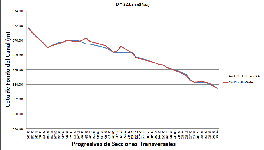
The research work presented was carried out with the purpose of evaluating GISWater and HECgeoRAS Geographic Information System (GIS) related tools, which function as a connection node between the HEC-RAS model and the QGIS and ArcGIS software respectively. . Here the conditions of creation of the digital model of the land are leveled, with the purpose of obtaining a final result from a parity of circumstances. The case study chosen to obtain the results was the Quebrada Borure located in the city of Barquisimeto, State of Lara, Venezuela. Once both solutions provided by the HEC-RAS hydraulic modeler were obtained, the correlation between both products was determined, being high, close to the value of the unit, reason why it could be concluded that both tools are applicable in the data processing for the HEC-RAS model, with the advantage that GISWater is a free license and works under the geographic information system QGIS with the same characteristics
Downloads
References
2. US Army Corps of Engineers, «HEC-RAS User´s Manual», Version 4.1. US Army Corps of Engineers, Davis, 2010
3. C. T. Ackerman, «HEC-GeoRAS; GIS Tools for support of HEC-RAS using ArcGIS», United States Army Corps of Engineers, Davis, 2005
4. Compañía de aguas de Cataluña, «Manual de usuario GISWATER 3», España, 2018
5. A. Kossowski e I. Rupcich, «Evaluación desde el punto de vista hidráulico del puente sobre la quebrada Borure, Municipio Iribarren, Edo Lara, mediante la aplicación de los programas Hec-ras y Hec-georas», Tesis de Pregrado, Decanato de Ingeniería Civil, Universidad Centroccidental Lisandro Alvarado, Venezuela, 2013
6. J. Duque Matínez, «Comparación estadística de métodos interpolación determinísticos y estocásticos para la generación de modelos digitales del terreno a partir de datos LIDAR, en la parroquia de Tumbabiro, cantón San Miguel de Urcuquí, provincia de Imbabura»,Tesis de Licenciatura, Quito: USFQ, 2015
Published
How to Cite
Issue
Section
The opinions expressed by the authors do not necessarily reflect the position of the editor of the publication or UCLA. The total or partial reproduction of the texts published here is authorized, provided that the complete source and electronic address of this journal is cited. Authors have the right to use their articles for any purpose as long as it is done nonprofit. The authors can post on the internet or any other media the final approved version of their work.


.png)